Project
Community
News
My App
My maps
Maps of Liphook
Advanced search
All
Private
Favorites
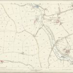
Sussex X.1 (includes: Bramshott; Whitehill) - 25 Inch Map
1869|Ordnance Survey
1:2 500
Sussex X.2 (includes: Bramshott) - 25 Inch Map
1869|Ordnance Survey
1:2 500
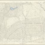
Surrey XLIV - OS Six-Inch Map
1871|Ordnance Survey
1:10 560
Surrey XLIV & XLV Parts - OS Six-Inch Map
1869|Ordnance Survey
1:10 560
Hampshire & Isle of Wight XLIV - OS Six-Inch Map
1869|Ordnance Survey
1:10 560
Sussex X - OS Six-Inch Map
1873|Ordnance Survey
1:10 560
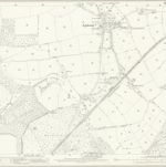
Sussex X.6 (includes: Bramshott; Iping; Stedham; Trotton) - 25 Inch Map
1868|Ordnance Survey
1:2 500
1600
1650
1700
1750
1800
1850
1900
1950
2000
History
Old maps of Liphook
Discover the past of Liphook on historical maps
Old maps of Liphook
Discover the past of Liphook on historical maps
Explore Maps
Discover History
Parent places
East Hampshire
Related places
© MapTiler
© OpenStreetMap