Project
Community
News
My App
My maps
Maps of Kirriemuir
Advanced search
All
Private
Favorites
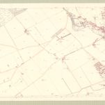
Forfar, Sheet XXXI.16 (Kirriemuir) - OS 25 Inch map
1862|Ordnance Survey
1:2 500
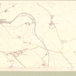
Forfar, Sheet XXXII.13 (Kirriemuir) - OS 25 Inch map
1859|Ordnance Survey
1:2 500
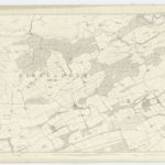
Forfarshire, Sheet XXXI - OS 6 Inch map
1862|Ordnance Survey
1:10 560
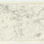
Forfarshire, Sheet XXXII - OS 6 Inch map
1859|Ordnance Survey
1:10 560
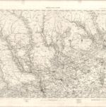
Blairgowrie - OS One-Inch map
1859|Ordnance Survey
1:63 360
Angusshire S.
1832|Thomson, John
1:100 000
Perthshire NE.
1832|Storie, James
1:131 000
1600
1650
1700
1750
1800
1850
1900
1950
2000
History
Old maps of Kirriemuir
Discover the past of Kirriemuir on historical maps
Old maps of Kirriemuir
Discover the past of Kirriemuir on historical maps
Explore Maps
Discover History
Parent places
Great Britain
Related places
© MapTiler
© OpenStreetMap